
Drone Flight Solutions & Services
Save significant time, money, and resources by leveraging Drone-as-a-Service technologies. Let Cloud 9 connect you with the right vendors for your specific industry and solution needs. Whether you are inspecting cell towers, solar panels, or high-voltage transmission lines, reviewing insurance claims, or comparing plans to as-built project progress, Cloud 9 will find you the right Drone Service vendor to improve your productivity, effectiveness, and profitability by making drones part of your data collection and analysis process.

Experienced
Licensed
Pilots
Intelligent
Data
Collection
Cloud-based
Collaborative
Platform
Complete
Project
Management
Industries
- Agricultural, Forestry, Mining
- Architecture, Engineering, Construction
- Cinematography
- Energy and Utility
- Federal, State, Local Government and Municipality
- Geological
- Insurance
- Marketing and Events
- Real Estate and Property Management
- Roofing
- Solar and Wind Energy
- Telecommunications
- Transportation and Rail
Services
- Complete Project Management
- Drone Flight Services
- Collaborative Cloud-based Image Management Platform
- Image & Data Analytics
- Operations Consulting & Training
- 4K video for cinematography projects
- Drone Photography
- Thermal Inspection Imaging and Reports
- Aerial Survey and Mapping
- 3D Point Cloud and Mesh Modeling
- Construction Progression Monitoring
- Digital Surface Modeling and Contour Mapping
- Insurance Storm Damage Reports
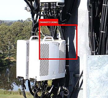
- Power and Utility Inspection and Reports
- Commercial Building Façade Mapping
- Agricultural Index Analytics
Applications
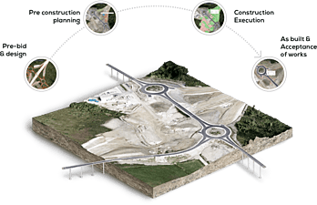
- Routine Drone Mapping for detailed progress of build project
- BIM File import and overlay
- Monitor job progress & earthmoving operations
- Compare design plans to as-built
- Orthomosaics
- Map creation
- Digital Surface Modeling (DSMs)
- 3D point clouds
- Object Detection and Classification
- Orthomosaic
- 3D Point Cloud
- 3D Mesh
- Change View
- Comparison View
- Source Images
- Custom Contours
- Slope Maps
- Dynamic Digital Surface Model
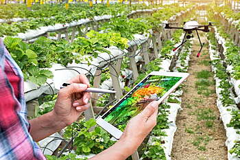
- High-value Crop Monitoring
- Field and individual plant inspections
- Examine LiDAR and photogrammetry
- Analyze vegetation growth and maintenance activities
- Automated stockpile identification and volume
- Statistics dashboard
- Stockpile location map and inventory
- Stockpile inventory report